Wednesday, June 30, 2010

Crown Cove (#19)

June 24, 2010- ...as I was saying, I was drawn, almost magnetically, into this dark cave, a seemingly endless tunnel... well, okay, technically there was light at the other end...

so I plummeted head first into the abyss.
Kinda creepy huh? At least a little suspenseful, right?


...and when I popped out other side,
into a totally new dimension,
I found myself in "Aquatic Land!"


Actually it was Crown Cove on the bay-side of Siverstrand. As I continued on I was surprised to find a white sand beach bordered by the perfectly blue bay and accented with a few catamarans for good effect. So California, don'tcha think?


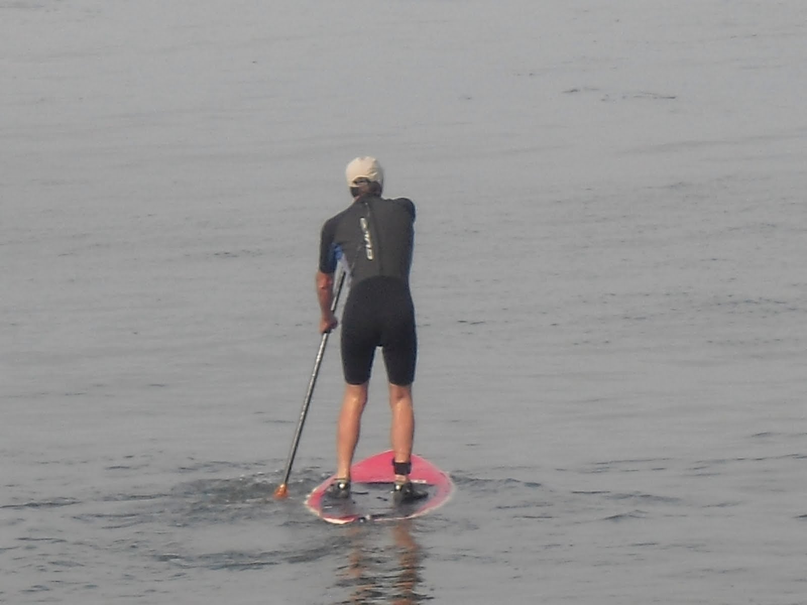
Equally surprising, but much better than a trendy sailboat, I stumbled upon my wife with a few of our kayaks. I was convinced that she was ready to use her womanly wiles to coax me into a little "paddle about."

She explained that I could overlook a minor detail by 1) changing my blog to "Paddling" Here and There, or 2) pretending I am simply walking on my hands.

Either way, she convinced me... and out to the bay we paddled.


Did I tell you my wife is a much better paddler than I? Well she is.

My primary goal was to make it to this pretty little point a couple hundred yards away.


As I was feeling personally pleased with myself to make it that far, she went into high gear and paddled on,


and on. Her sights were clearly set on the Coronado Bridge off in the distance.


And then..., hey, looky there! That's where one of my most awesome cousins live.


Where was I? Oh yes, and then the entire West Coast Seal Team marched out in front of us in full gear. They must have seen me taking pictures of them cause there was a lot of very loud yelling.


Then commandos in boats approached us, acting all friendly, trying to get us to come close enough to get us...


As if that wasn't intimidating enough, they sicked this big destroyer on us...


Needless to say, we turned around post haste and head straight for Lowe's Resort and the Coronado Cays.


I learned something about my wife that day. She had been holding back on me all these years. I discovered that she could paddle at least ten times faster than I thought. Guess she didn't care so much for the military operations.


Okay, so one or two of my reflections here were uncharacteristically exaggerated and not entirely true... for instance, I am really a much better kayaker than I let on.


So then back to the beach what do we find?
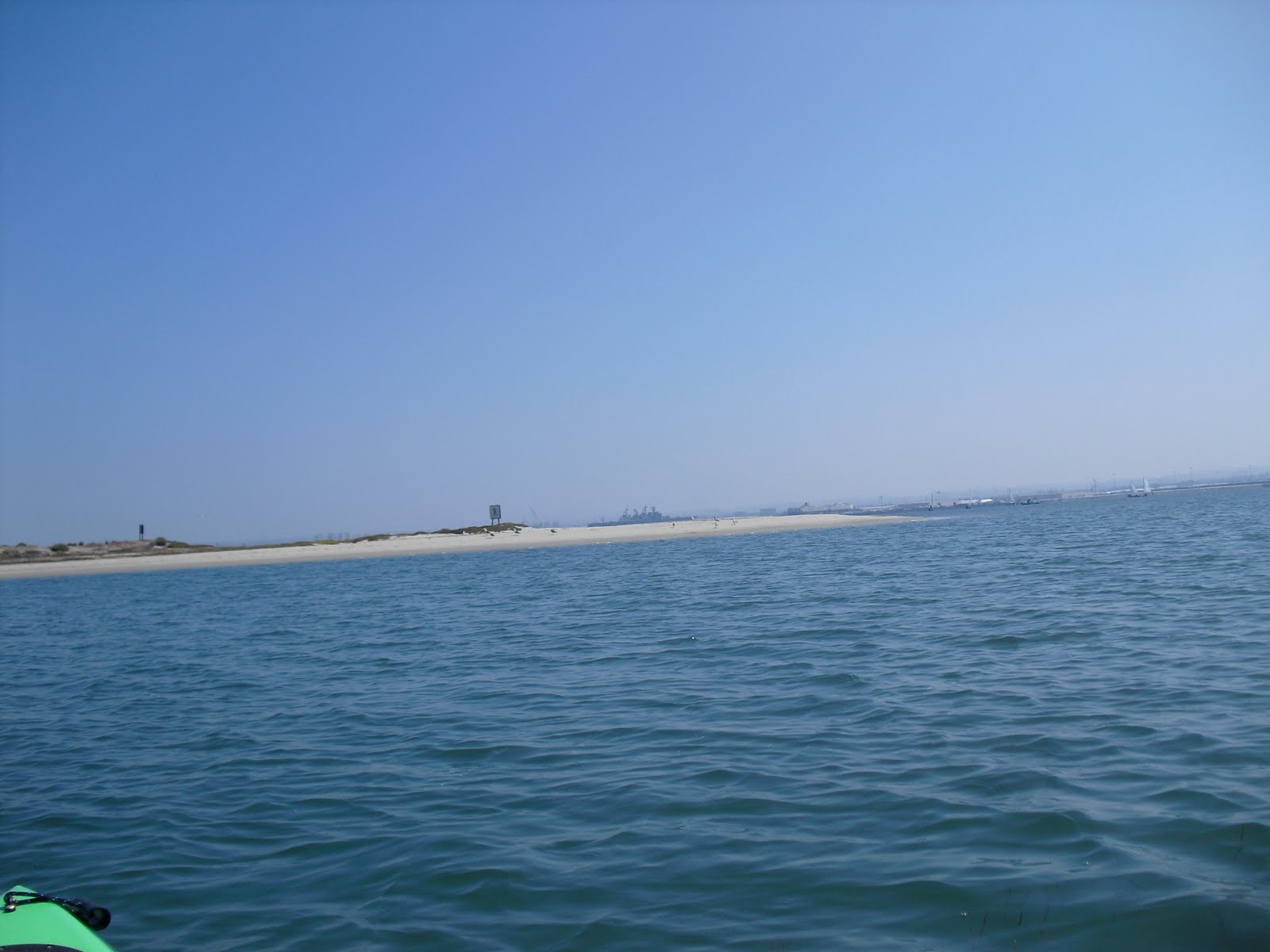


One of our sons showing off!

Tuesday, June 29, 2010

Silverstrand State Beach (#18)


June 24, 2010-

Situation: Camping at the
Silver Strand State Beach nestled on the shore between Imperial Beach and Coronado.

Interest: Going for a walk.

Option: North to Coronado or South to I.B.

Decision: Are you kidding me?! I.B., of course!

So I go off on my merry way, barefoot on the beach strolling south from in front of the campground.

I pass the lifeguard tower to my left and look out over the ocean to take in a view of the Coronado Islands.


It was a fantastically beautiful day - sunny, blue water, blue sky, warmish water and sandy sand. Don't get much better than that!


I'm thinking about my plan to walk down all the way to the radio station when what do I see but these big beautiful kites. BIG kites! Looked like parachutes or something.


Then do you know what I saw? A guy hanging onto one of those kites was actually surfing! Geez; who says guys can't multi-task?


Speaking for myself, when
I was a kid, I laid down on my board, paddled out, and let the waves provide the power. Guess I'm getting old.


On another note, do you remember the ship that was about to crash into the Coronado Bridge when I was walking the Spanish Landing? Well I guess it didn't collide after all because there it was just chugging along. You can tell its the same one because of its unique hull and cone shaped towers.

Anyway, I walked and walked and walked for quite some time before I finally reached the radar post surrounded by the very high circular fence. Its been there longer than the 34 years that I have been in this neck of the woods.

Did I mention that walking long distances bare foot is not really a great idea? Well, it's not.

I could have, and probably should have, turned around right there but I.B. was so close I couldn't help myself. I continued on with a new goal: the north jetty.


Needless to say, I made it. That's the good thing.


Bad news, as I turn and look back north from whence I came, my feet were freaking killing me and I still had the 3 1/2 mile return trip to manage. Brilliant!


I survived though, thank you very much. And when I returned I found this interesting little cave. A black hole if you will.

All of a sudden I felt drawn to it, as if by some magnetic force and...


Sunday, June 27, 2010

Salton Sea; Ironwood Nature Trail (#17)

June 17, 2010 -
We happened to be on our way home to San Diego from Palm Springs, CA when we decided to take a detour around the
Salton Sea.

Even though
it was hours out of our way, in 100 degree weather, it mostly made sense because we had never been there before.

The Ironwood Nature Trail is, in fact, a 2 mile round trip hike to Mecca Beach and back from the Salton Sea State Recreation Center on the north shore of this truly immense body of water.

The truth is that I hiked all of 100 yards, at most, and that was for a very good reason: It was simply too damn hot to walk! Something about summertime in the desert I guess.

We drove Highway 111 South down the east side of the "sea" and happened ourselves into this state park which, as state parks tend to do, charged $10 (honor system) to enter.

Birds! Some 350 species of them have been counted here according to those who seem to know. In fact we were gracefully greeted by this statuesque "bird-on-a-post" when we first arrived at the beach.

And then we spied some more birds... and a few more birds. Some of them, apparently endangered and nesting, prevented us from walking down to the water in this particular spot.

Walking south past the visitor center this beautiful small lagoon, with more birds, came into view.

Walked another steamy 80 yards and actually made it to a shoreline which, frankly, was not all that appealing.

From there I did at least get a good view of the mountains beyond the west side of sea.

And looking south, the view was endless. Literally. Bigger than Lake Tahoe I tell you.

You might already know that the Salton Sea is below sea level and that it was formed on an ancient sea bed.
It also lies directly on the San Andreas Fault.

BUT! (and that's a big but) Did you know that it was really formed over the period of two years beginning in 1905 when rain and snow melt caused the Colorado River to swell overrunning an Imperial Vally Dike. The result was that water from two newly created rivers (Alamo River and New River) flowed freely there for two years. That's a lot of water!

Nominations for the "biggest highlight of this non-hike award" would definitely include this state of the desert art recreation center!


Sunset Cliffs Trail (#16)

June 13, 2010 -

I admit to being a recovering surfer but I can't resist returning to the scene of the crime. Sunset Cliffs, for me, was only surpassed by my home turf (I.B.) when it came to favorite surf spots.

Over the hundred or so times I've surfed there, not once did I think to myself, "What a nice place to go for a walk." Probably because at the time I didn't derive much pleasure from just walking and, besides, I would have just jumped in the water anyway.

Well, I can say it now... "Wow, what a nice place for a walk!"

You get to "The Cliffs," by taking Highway 8 West to... ding, ding, ding! you guessed it... Sunset Cliffs Boulevard.

The trail begins along the coast a half mile past Ocean Beach driving south where you'll find a convenient little parking lot on the bluffs.

The rock formations and the way the ocean interacts with the land is awesome. Unfortunately, I suppose, there are very few sand beaches along the way and even those are tricky to get to.

I guess that's why its called Sunset "Cliffs'" not Sunset "Sandy Beaches."

Although the path paralleled the road as I walked, my attention was always on the trail, the cliffs, the birds, the waves, etc., so I hardly noticed the cars and such.

The only exceptions to that were the few times where the "unstable cliffs" proved worthy of their name.

One of my sons likes to play a hypothetical game that goes something like this: "Which would you rather, getting hit by a car or falling off a 100 ft. cliff?" You get my point right?

I was very excited to show Wilson my favorite surf spot along the cliffs. The waves get so good here that at some point in time, and certainly at great expense, stairs were erected to make it possible to get to them.

As you can probably tell by the photo, Wilson was a little leery about our trip down to the water.

The name of the break directly in front of the steps is called South Garbage, but the name certainly does not pertain to the quality of the surf. Today the surf was small, but, as usual, had very good form.

One thing to know about surfing here is that it can be tricky getting in and out of the water when the waves are big. This is one of only two places where I surfed waves 20 ft. plus and I don't exactly remember which was scarier - surfing the waves, or getting pummeled on the rocks by them trying to get back on dry land. "Which would you rather...?"

Just as I was sharing this story with Wilson we both looked up to see this guy damn near walking on water. Speaking for myself, when "I" was a surfer, I paddled out the old fashioned way - laying down on the board and paddling with our hands. Go figure.

While at the bottom we looked south toward Ratkay Point and Newbreaks. There's actually a stretch of sand beach and some tide pools to be explored but we decided to go back up and continue on the trail up above.

Right at the steps you find a sign inviting you to continue on to a portion of the trail that parts ways with the asphalt road (the street itself makes a 90 degree bend and ends there).


This next portion of trail I've really only been on a couple of times and one of those instances was around midnight on a full moon.


A wannabe accountant (we were both in the same class at SDSU) and obviously hopeless surf freak (another shared quality) invited me on a night-time surf sesh at Newbreaks that he'd been planning for months.


Surfing by moonlight is a one of a kind experience and was well worth that challenge of descending, using a strategically placed rope, a steep slippery trail in the dark with a board in your hand. The tube rides were magical, with the moonlight shimmer sparkling up the face of the waves in front of you.


This picture to the right is a photo of Newbreaks by daylight


Eventually the trail ended when we ran into Point Loma Nazarene College. So, guess what? We turned around and head back.

Our entire walk was about four miles and Wilson, save the part about the steps, enjoyed every bit of it.


The last three pictures show:


1) The view heading back north,


2) A shot of the fenced in "blowhole." I wonder how many people fell into it before the fence went up.


3) The beginning of the trail looking north to Ocean Beach. In fact you can kind of see the pier.

Another splendid trek!


MAP