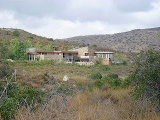
September 9, 2010 - Today I hiked a short 2 1/2 mile trail known as the Visitor Center/Oak Grove Double Loop in the Mission Trails Regional Park (MTRP). This walk starts near the MTRP entrance off of Mission Gorge Road and links the Oak Grove Trail with the Visitor Center Loop. MTRP encompasses a large area, over 5800 acres, and according to Wikipedia is the 6th largest municipally- owned park in the United States and the largest in California. There are a variety of hikes to choose from here. In fact, Lake Murray (#24), where I hiked back in July, is part of this regional park as well. The first portion of this little trek, the Oak Grove Trail, was only about a mile but was my favorite since, as the name implies, it was somewhat wooded. The path meandered eastward for a ways then bent back around west and dipped down through a small (guess what?) oak grove before coming back to the visitor center. A neat little Native American brush hut sat along the trail, but I'm guessing that the natives of the time didn't have the same iron re-bar that supports this quaint little replica. While I didn't go inside to check out the Visitor Center, based on what I've read I get the impression that it is state of the art and it certainly looks very nice from a distance. As I walked this part of the loop something struck me in the head like a brick. Mission Gorge Road! Most San Diegans, like me, would certainly be aware of Mission Gorge Road. I have been familiar with that street name for over 30 years and not thought twice about the significance of it. And now, all of a sudden, I'm walking on a trail that I got to by driving on "Mission Gorge" Road and find myself, according to the little map I was looking at, in view of... Mission Gorge!! Eventually, walking west, I found the connecting trail that crosses the San Diego River and heads up to Fortuna Mountain which would be a hike for another day since, for some safety reason unknown to me, the trail was closed. Ultimately, the path curved back around finally depositing me where I started. I already know I'll return to MTRP a few more times in the near future to hike to the Old Mission Dam, to check out Kumeyaay Lake, and to climb Cowles Mountain. Until then... Another Great Hike! MAP |
"Join me and Wilson as we walk/hike, obsessively, around and throughout San Diego County and beyond, while photo-journaling our experiences on this here bloggy-thingy."
Wednesday, September 22, 2010
Mission Trails Regional Park: Visitor Center/Oak Grove Double Loop (#33)
Subscribe to:
Post Comments (Atom)


No comments:
Post a Comment